The Planning for Sea Level Rise in the Matanzas Basin project has released its final, 304-page findings report: Planning for Sea Level Rise in the Matanzas Basin: Opportunities for Adaptation. Accompanying the report are 13 appendices, which provide additional details of the project’s analytic methods, findings, and adaptation strategies. Also available are the GIS data gathered and produced by the project.
The report is the culmination of over 3 years of sea level rise adaptation planning and public involvement led by an interdisciplinary team from the Guana Tolomato Matanzas (GTM) National Estuarine Research Reserve and the University of Florida, and a 14-member stakeholder Steering Committee. Funding was provided by the National Estuarine Research Reserve System Science Collaborative, a partnership between the University of New Hampshire and the National Oceanic and Atmospheric Administration (NOAA).
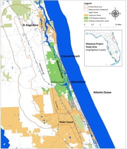
The report’s main audiences are the GTM Research Reserve, and leaders, stakeholders, and citizens in the Matanzas study area in St. Johns and Flagler counties. The 264,000-acre study area, with a total population around 150,000 people, includes the cities of St. Augustine and Palm Coast, and many smaller incorporated and unincorporated communities.
Project study area
The project analyzed current and potential future conditions under scenarios of less than the historic rate of sea level rise (10 inches over the past 100 years) up to a rise of 8 feet (2.5 meters) by the year 2100. The mid-range scenario of 3 feet (1 meter) rise by 2100 could occur as early as 2075.
The project’s main findings relate to the importance of the Matanzas Basin, its vulnerabilities, potential adaptation strategies, and current governance capacity.
Importance of the Matanzas Basin
The Matanzas Basin has rich biodiversity, intact ecosystems, and environmental and cultural assets of state and national significance. The basin’s ecological resources deliver valuable ecosystem services to area residents and businesses. The high population growth rates in the two counties have the potential for creating future land use conflicts between conservation and development interests.
Vulnerabilities
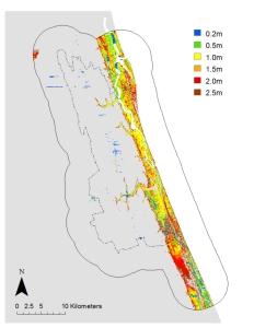
The large study area afforded landscape-level assessments of multiple types of vulnerabilities through integrated, scenario-based geospatial analyses. Sea Level Rise Affecting Marshes Model (SLAMM) analyses drew attention to a 2-mile wide strip of coastline as being highly vulnerable to sea level rise (see figure below). Inland impacts of sea level rise were limited and concentrated along the major streams, such as Pellicer Creek, due to the higher elevations of the Atlantic Coastal Ridge. Just to the west of the study area, future sea level rise impacts were observed in the Lower Eastern Valley due to rising of the St. Johns River.
Areas of change shown for each sea level rise scenario (using SLAMM)
Impacts of sea level rise on the natural environment. Some wetland and open water dependent species gained habitat with sea level rise, however the majority saw net loss in habitat. Many of the habitat losses occurred within the GTM Research Reserve, which suggests the need for additional conservation lands to mitigate the losses. Biodiversity hotspots within the basin, such as along Pellicer Creek, had a moderate to high degree of impact.
Impacts of sea level rise on existing development. Residents and stakeholders described current conditions – erosion, flooding, saltwater intrusion, and loss of natural amenities – that may become more severe as sea level rises. The project found that for all the sea level rise scenarios there were forecasted losses of currently developed land, assuming the land is not protected from inundation. In the Matanzas study area, the 3 feet sea level rise scenario affected 2,456 acres of currently developed residential land, which has over 16,000 residential units with more than 30,000 residents.
Impacts of sea level rise on future development. All the sea level rise scenarios forecasted losses of undeveloped dry land, assuming the land is not protected from inundation. In the Matanzas study area, the 3 feet sea level rise scenario affected 1,637 acres of vacant, developable residential land. Under current growth rates, if future development (a) avoids areas vulnerable to 3 feet sea level rise and follows current land use policies, and (b) accommodates the relocation of current development in vulnerable areas, then by 2060 this new development was found to consume property parcels totaling 133,564 acres across the two counties. Currently platted parcels absorbed much of the growth and relocation.
Impacts of future development on the future natural environment. The future development scenario described above impacted nearly all upland natural community types. Many upland species lost 10% to 30% of their habitat to future development, and biodiversity hotspots were affected.
Adaptation Strategies
The large study area and its diversity of land uses led to the identification of a wide range of potential adaptation strategies. Many of the strategies are multi-functional, and oriented towards regional sustainability and resilience, thus they are likely to yield benefits for all future sea level rise scenarios.
Future conservation priorities. Future conservation priorities highlighted undeveloped areas directly north and south of the GTM Research Reserve to compensate for the loss of estuarine habitats within the Reserve. In upland areas, lands having high conservation priorities included habitats around Pellicer Creek. Aggregated conservation priorities for regional resilience covered most of the Matanzas Basin, which stressed the importance of continuing initiatives for land conservation and best management practices.
Future development to reduce impacts to future conservation priorities. Similar to the “trend” development scenario discussed above, a future “conservation” development scenario was created, which resulted in new development occupying 13,747 fewer acres in total, and impacting 63,800 fewer acres of future conservation priorities, as compared to the trend scenario for the two counties. Within the Matanzas study area, the conservation scenario impacted 20,259 fewer acres of future conservation priorities. The results indicate that policies guiding density and location of development are important for conservation, and that improvements over current land use policies are possible.
Coastal hazard mitigation. To attend to the worsening threats to development from coastal hazards, the project created a toolbox of hazard mitigation strategies modified to explicitly address sea level rise and apply to the Matanzas area. Of particular interest are strategies that integrate designs for the built and natural environments, and that acknowledge the unique challenges posed by adaptation of historical assets.
Governance Capacity and Next Steps
In order to understand the governance context, the project reviewed local and regional initiatives and policies for the goals of land conservation, smart growth, coastal hazards mitigation, and sea level rise adaptation. The review noted early leadership at the level of the Northeast Florida region, however local government plans in the Matanzas area had not yet begun to recognize and address the long-term threat of sea level rise.
The project’s public input showed that Matanzas area stakeholders and citizens are ready to increase attention to sea level rise concerns. The GTM Research Reserve and the project’s Steering Committee reported that they were already using the information and data from the project, by incorporating it into regular operations and the design of new initiatives. The project’s findings represent a better understanding of the Matanzas area and its future, yet the project was only the beginning of adaptation planning. This work should be regularly updated and combined with information about other future changes as it becomes available.


