Heritage at Risk

Flagler College view

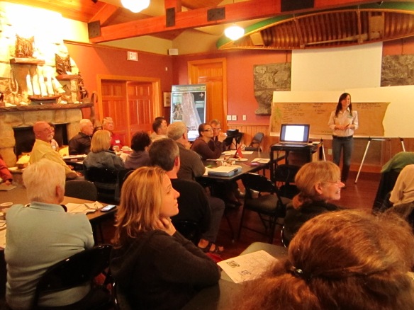
Principal investigator, Dr. Kathryn Frank, spoke about the Planning Matanzas project at Flagler College on February 10th. Her presentation was part of a year-long speaker series, Heritage at Risk: Climate Change, Coastal Communities & Cultural Resources. In conjunction, Jacksonville’s Florida Times-Union newspaper ran an article on February 16th that featured the Matanzas project and other sea level rise planning initiatives in St. Augustine.

Final Report, Appendices, and GIS Data

Planning_For_Sea_Level_Rise_In_The_Matanzas_Basin cover

The Planning for Sea Level Rise in the Matanzas Basin project has released its final, 304-page findings report: Planning for Sea Level Rise in the Matanzas Basin: Opportunities for Adaptation. Accompanying the report are 13 appendices, which provide additional details of the project’s analytic methods, findings, and adaptation strategies. Also available are the GIS data gathered and produced by the project.

The report is the culmination of over 3 years of sea level rise adaptation planning and public involvement led by an interdisciplinary team from the Guana Tolomato Matanzas (GTM) National Estuarine Research Reserve and the University of Florida, and a 14-member stakeholder Steering Committee. Funding was provided by the National Estuarine Research Reserve System Science Collaborative, a partnership between the University of New Hampshire and the National Oceanic and Atmospheric Administration (NOAA).

The report’s main audiences are the GTM Research Reserve, and leaders, stakeholders, and citizens in the Matanzas study area in St. Johns and Flagler counties. The 264,000-acre study area, with a total population around 150,000 people, includes the cities of St. Augustine and Palm Coast, and many smaller incorporated and unincorporated communities.

Project study area
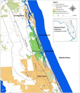
Matanzas project study area

The project analyzed current and potential future conditions under scenarios of less than the historic rate of sea level rise (10 inches over the past 100 years) up to a rise of 8 feet (2.5 meters) by the year 2100. The mid-range scenario of 3 feet (1 meter) rise by 2100 could occur as early as 2075.

The project’s main findings relate to the importance of the Matanzas Basin, its vulnerabilities, potential adaptation strategies, and current governance capacity.

Importance of the Matanzas Basin

The Matanzas Basin has rich biodiversity, intact ecosystems, and environmental and cultural assets of state and national significance. The basin’s ecological resources deliver valuable ecosystem services to area residents and businesses. The high population growth rates in the two counties have the potential for creating future land use conflicts between conservation and development interests.

Vulnerabilities

The large study area afforded landscape-level assessments of multiple types of vulnerabilities through integrated, scenario-based geospatial analyses. Sea Level Rise Affecting Marshes Model (SLAMM) analyses drew attention to a 2-mile wide strip of coastline as being highly vulnerable to sea level rise (see figure below). Inland impacts of sea level rise were limited and concentrated along the major streams, such as Pellicer Creek, due to the higher elevations of the Atlantic Coastal Ridge. Just to the west of the study area, future sea level rise impacts were observed in the Lower Eastern Valley due to rising of the St. Johns River.

Areas of change shown for each sea level rise scenario (using SLAMM)
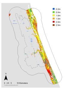
SLAMM changes

Impacts of sea level rise on the natural environment. Some wetland and open water dependent species gained habitat with sea level rise, however the majority saw net loss in habitat. Many of the habitat losses occurred within the GTM Research Reserve, which suggests the need for additional conservation lands to mitigate the losses. Biodiversity hotspots within the basin, such as along Pellicer Creek, had a moderate to high degree of impact.

Impacts of sea level rise on existing development. Residents and stakeholders described current conditions – erosion, flooding, saltwater intrusion, and loss of natural amenities – that may become more severe as sea level rises. The project found that for all the sea level rise scenarios there were forecasted losses of currently developed land, assuming the land is not protected from inundation. In the Matanzas study area, the 3 feet sea level rise scenario affected 2,456 acres of currently developed residential land, which has over 16,000 residential units with more than 30,000 residents.

Impacts of sea level rise on future development. All the sea level rise scenarios forecasted losses of undeveloped dry land, assuming the land is not protected from inundation. In the Matanzas study area, the 3 feet sea level rise scenario affected 1,637 acres of vacant, developable residential land. Under current growth rates, if future development (a) avoids areas vulnerable to 3 feet sea level rise and follows current land use policies, and (b) accommodates the relocation of current development in vulnerable areas, then by 2060 this new development was found to consume property parcels totaling 133,564 acres across the two counties. Currently platted parcels absorbed much of the growth and relocation.

Impacts of future development on the future natural environment. The future development scenario described above impacted nearly all upland natural community types. Many upland species lost 10% to 30% of their habitat to future development, and biodiversity hotspots were affected.

Adaptation Strategies

The large study area and its diversity of land uses led to the identification of a wide range of potential adaptation strategies. Many of the strategies are multi-functional, and oriented towards regional sustainability and resilience, thus they are likely to yield benefits for all future sea level rise scenarios.

Future conservation priorities. Future conservation priorities highlighted undeveloped areas directly north and south of the GTM Research Reserve to compensate for the loss of estuarine habitats within the Reserve. In upland areas, lands having high conservation priorities included habitats around Pellicer Creek. Aggregated conservation priorities for regional resilience covered most of the Matanzas Basin, which stressed the importance of continuing initiatives for land conservation and best management practices.

Future development to reduce impacts to future conservation priorities. Similar to the “trend” development scenario discussed above, a future “conservation” development scenario was created, which resulted in new development occupying 13,747 fewer acres in total, and impacting 63,800 fewer acres of future conservation priorities, as compared to the trend scenario for the two counties. Within the Matanzas study area, the conservation scenario impacted 20,259 fewer acres of future conservation priorities. The results indicate that policies guiding density and location of development are important for conservation, and that improvements over current land use policies are possible.

Coastal hazard mitigation. To attend to the worsening threats to development from coastal hazards, the project created a toolbox of hazard mitigation strategies modified to explicitly address sea level rise and apply to the Matanzas area. Of particular interest are strategies that integrate designs for the built and natural environments, and that acknowledge the unique challenges posed by adaptation of historical assets.

Governance Capacity and Next Steps

In order to understand the governance context, the project reviewed local and regional initiatives and policies for the goals of land conservation, smart growth, coastal hazards mitigation, and sea level rise adaptation. The review noted early leadership at the level of the Northeast Florida region, however local government plans in the Matanzas area had not yet begun to recognize and address the long-term threat of sea level rise.

The project’s public input showed that Matanzas area stakeholders and citizens are ready to increase attention to sea level rise concerns. The GTM Research Reserve and the project’s Steering Committee reported that they were already using the information and data from the project, by incorporating it into regular operations and the design of new initiatives. The project’s findings represent a better understanding of the Matanzas area and its future, yet the project was only the beginning of adaptation planning. This work should be regularly updated and combined with information about other future changes as it becomes available.
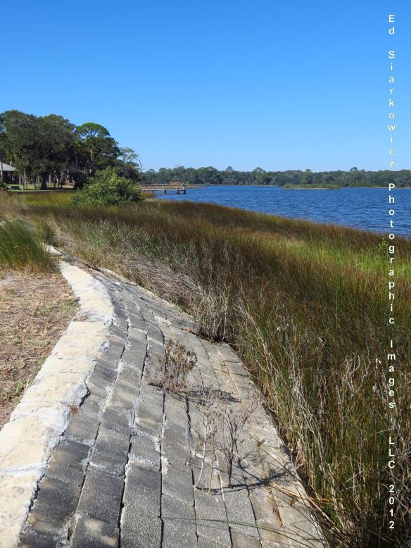
Princess PlacePrincess Place, Flagler County/GTM Research Reserve

Announcement – Final Public Workshop on September 8

The final workshop for the “Planning for Sea Level Rise in the Matanzas Basin” project is scheduled for Monday, September 8, 2014, from 10:00 a.m. to 2:00 p.m. To give participants a chance to interact with project leaders, registration time slots are available each half hour from 10:30am to 12:30pm. The event will be held at Whitney Lab for Marine Biosciences, 9505 Ocean Shore Boulevard in the Town of Marineland.

The final workshop will be held in an open house format. Groups will move through stations to learn about the different components of the project, ask questions, and provide feedback. Project team members and community partners will give presentations. The topics are:

  1. Project overview
  2. Local values of the Matanzas Basin
  3. Sea level rise impacts on the GTM properties
  4. Sea level rise impacts on St. Augustine, Palm Coast and Barrier Islands
  5. Potential adaptation strategies for St. Augustine, Palm Coast and Barrier Islands
  6. Conservation priorities for sea level adaptation and eco-protection
  7. Future development scenarios
  8. Additional potential sea level rise adaptation strategies for GTM
  9. Adaptive capacity and readiness
  10. Ways everyone can be involved

The final workshop is the culmination of several phases of public input over the past three years. The first phase included stakeholder workshops to residents, youth, and professional groups. The research team presented the science of sea level rise, localizing impacts to the Matanzas basin and the surrounding region. Input was gathered from participants about area attributes through a visioning exercise and adaptation strategy preferences with participation in a role play game.

The second phase of public input was the multi-stakeholder workshop. The focus was the intersection between sea level rise, land conservation priorities, and future land development in the region. Part of the process involved the group contemplating the design of conservation corridors to protect habitats of various species whose future would be impacted by sea level rise and development practices. Using a land density exercise, workshop participants were also given the opportunity to envision the degree of density future residents in the area would need to congregate, in order to ensure the availability of natural habitat.

The upcoming event is free with light refreshments provided. To register, visit https://matanzasbasin.eventbrite.com.

Logo in Coast Picture

Youth Workshop – Middle School

When sea level rise accelerates, who will it impact the most? The next generation of planners, government officials, residents, and business owners may be young right now, but the importance of informing them and getting them engaged with the issue was not lost on the Matanzas sea level rise project team and steering committee. As with the college and high school student workshops in May, we recently engaged middle school students participating in the summer program at St. Johns Technical High School in St. Augustine to teach them about sea level rise, and to find out what they thought about the issue and what they value in their community.

GTM Research Reserve’s Coastal Training Program Coordinator, Tina Gordon, coordinated with teachers and administrators at St. Johns Technical High School to offer a sea level rise workshop to about 40 students in grades 6-8. The workshop was structured like the previous adult community and professional group formats. The content of the presentations, visioning, and role-play game remained the same, but it was re-worked to meet the curriculum level of the students.

The middle school students were most excited by the visioning exercise in which they told us what places and features were important, what services were important, and what they would do to plan for sea level rise. The students were also a great help in making suggestions to the team on future sea level rise education for their age group, including having students draw pictures of their communities and adaptation strategies. Like other youth participants in our workshops, the middle school students leaned more towards protection of places they loved through fortification such as sea walls than adults (who more often considered planned relocation), and the students desired to keep natural areas natural. The team will incorporate this input into the overall project, Planning for Sea Level Rise in the Matanzas Basin.

The project team would like to thank Linda Krepp and Wayne King for enabling their students’ participation, all of the teachers who assisted in our group activities, and the UF graduate students who facilitated the interactive activities.

Visioning

A student ranks the most important features of the Matanzas Basin and the needs for effective sea level rise planning.

Adaptive Strategy GameStudents play the adaptive strategy game with GTM Research Reserve Coastal Training Program Coordinator, Tina Gordon.

Ecosystem Services and Sea Level Rise

Ecosystem services are the various benefits (goods and services) that humans receive from natural systems such as estuaries, wetlands, and forests. These services are often undervalued and taken for granted. The international Millennium Ecosystem Assessment identified four categories of ecosystem services: provisioning services such as food and water; regulating services such as flood and disease control; cultural services such as spiritual and recreational benefits; and supporting services such as nutrient cycling that maintain the conditions for life on Earth.

Sea level rise is threatening ecosystem services such as flood mitigation, storm surge protection, water quality treatment, and fisheries. For example, coastal marshes and estuaries provide habitat and nurseries for many species, including those important for the ecological food chain and human consumption through fishing and shellfish harvesting. As sea level rises, if the marshes retreat without suitable areas for new marshes, fisheries and wildlife will diminish. This will impact the local economy and quality of life. The potential negative impacts of sea level rise on ecosystem services, and consequently coastal communities, makes it critical to begin planning for future changes now.

The GTM Research Reserve recognizes the importance of ecosystem services to the local people and economies, and the importance of estimating the dollar value of the services. Reserve researchers have determined that the estuaries, marshes, swamps, forests, and marine areas of the Reserve currently provide $246 million per year of ecosystem services. One avenue of new research could be to identify how this value will be affected by sea level rise under different planning scenarios.

The video below shows in more detail the ecosystem services of the GTM Research Reserve.

University of Florida Homepage

Kathryn Frank for spotlight on sea level rise and urban planning . photographed on Mantanza Inlet near Crescent Beach

Kathryn Frank for spotlight on sea level rise and urban planning . photographed on Mantanzas Inlet near Crescent Beach

The University of Florida is currently profiling this project, Planning for Sea Level Rise in the Matanzas Basin, on its homepage. The true star of the accompanying video is the natural beauty of the Matanzas estuary. All of the amazing wildlife and scenic footage was taken during a two-hour tour aboard Ripple Effect’s veggie-powered boat with Capt. Chris Kelley at the helm. We wish to thank Chris Kelley, Eric Ziecheck, and everyone at Ripple Effect Ecotours for contributing so much to the video.

Workshop Presentations

Thank you to everyone who came to the Matanzas sea level rise planning workshops last week. A total of 100 people participated. We appreciate your time and effort, especially since the workshops were highly interactive. The workshop agenda was:

The project team will summarize participants’ adaptation planning preferences and post the summary to this website. We will bring these results together with those of other stakeholder group workshops in the spring, and the information will inform the next year of planning to develop future land use scenarios and an adaptation strategies toolbox for the region. We look forward to seeing everyone again as the project progresses.

Visioning Activity

Strategies Game

Class Project

In addition to the work of the project team, Dr. Kathryn Frank’s Advanced Environmental Planning class of six PhD and three masters students will have a semester long assignment to translate the completed technical analyses for the upcoming public workshops this Fall. Showing their commitment to the project, the class took a field trip to the Matanzas Basin on Labor Day. A highlight of the trip was a kayak tour of the Matanzas Estuary with Ripple Effect Ecotours. The class is excited to learn more about the communities and ecology of the Matanzas Basin, and to assist the region in planning for coastal change.

Third Steering Committee Meeting

Image

The project’s Matanzas Basin Steering Committee held their third meeting on August 13 near St. Augustine. The UF project team presented modeling results (maps) of potential sea level rise impacts on habitats and storm surge in the Matanzas Basin, and how these results may be used to design habitat migration corridors in the second year of the project (2013). The modeling results gave Steering Committee members a better understanding of the science of sea level rise and what it means for the basin and neighboring cities and communities. The results will also be presented at the upcoming public workshops in the Fall. The Steering Committee provided feedback to the project team about designing and scheduling these workshops. Individual members also video taped short messages about what makes the Matanzas Basis special and why it is important to plan for future sea level rise and other coastal changes. These videos will be shown at the public workshops. The project team greatly appreciates the guidance provided by the Steering Committee and their generous time commitment.

Image

Our Project Website and Blog

Welcome to the project website and blog for Planning for Sea Level Rise in the Matanzas Basin. The project began in November, 2011, and we now have this site to share our activities and progress with everyone. The website contains an events calendar and background information (such as in the About and FAQ pages), and the blog will provide project updates, interesting details, and opportunities for public input. The project runs until October 2014, so there is a lot yet to come. If you would like to receive email notice of all new posts, click “follow” in the lower right corner. We welcome your comments and questions at any time. Thank you for your interest in the project!

LOGO6 edge