As we’ve been examining the potential impacts of sea level rise in and around the Matanzas Basin, Ann Horowitz has been examining the potential impacts of sea level rise on historic St. Augustine. Horowitz recently connected with our project to share her findings. Specifically, Horowitz explored the effects of sea level rise on St. Augustine’s National Register historic districts and the need for adaptation as part of her historic preservation master’s thesis for Goucher College, near Baltimore, Maryland. She found that the impacts of sea level rise could significantly compromise the future of St. Augustine’s unique architectural and cultural heritage by 2100.
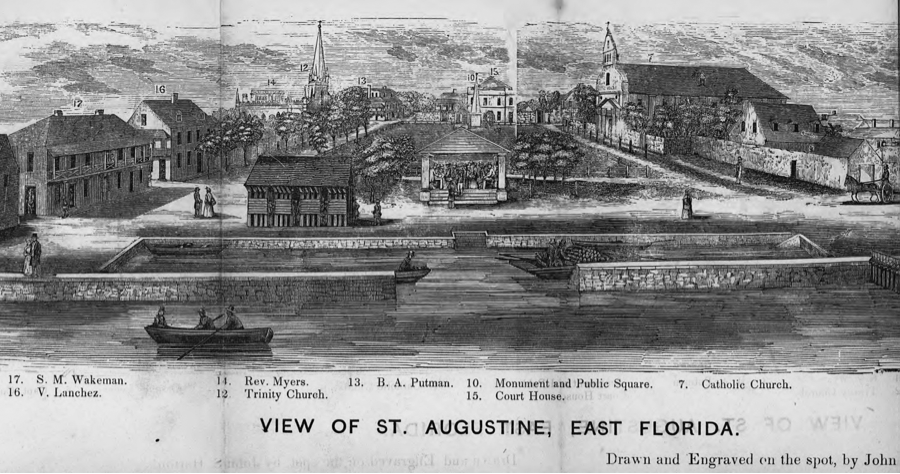
As Horowitz describes in her study, St. Augustine is no stranger to coastal adaptation. As early as 1599, the Spanish recognized the need for protection after a severe ocean storm damaged the early settlement. St. Augustine’s first seawall was constructed of timber between 1596 and 1602. Two coquina stone seawalls followed: Spain financed the first seawall completed in 1705 while the U.S. engineered the second between 1836 and 1842. (Fig. 1) The National Park Service constructed a rip-rap living seawall in 2011 to protect the nineteenth century historic seawall adjacent to the Castillo de San Marcos. (Fig. 2) In addition, the new Avenida Menendez seawall rehabilitates and protects the historic seawall between St. Francis Street to the Santa Marina Restaurant.
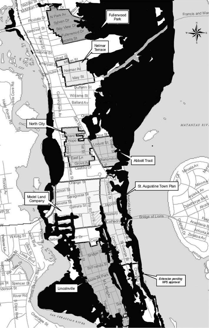
With a sea level rise projection of one foot by 2050, the shoreline could migrate closer to the historic district boundaries, increasing the probability of damaging floods, storm surge, and coastal erosion. A projected three-foot sea level rise by 2100 may permanently inundate portions of six St. Augustine historic districts. (Fig. 3) More frequent floods, higher storm surges, wetlands migration, and coastal erosion could impact all seven districts, resulting in the degradation or demolition of irreplaceable historic properties. For example, wetlands could migrate into the Lincolnville Historic District, potentially undermining the foundations of many historic buildings, leading to their collapse.
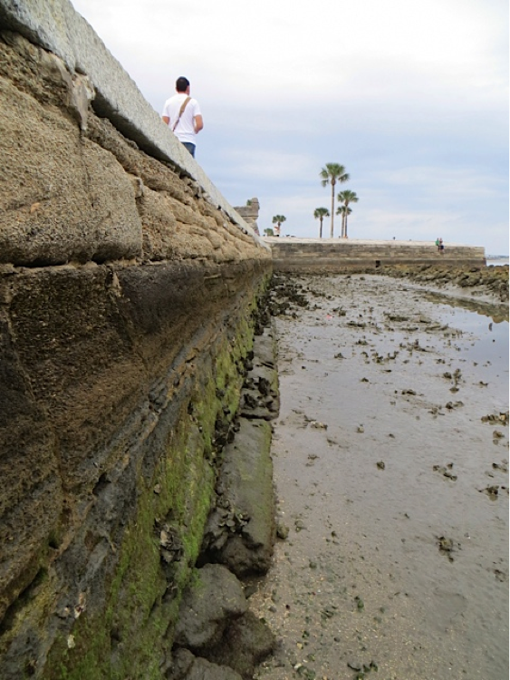
Furthermore, coquina stone and tabby are vulnerable to erosion and disintegration. (Fig. 4) Many of St. Augustine’s oldest historic buildings and structures are constructed with these lime-based building materials. Due to rising carbon emissions, the increasing acidity of ocean and rain water causes the dissolution of lime-based substances. Historic properties of coquina and tabby, such as the Castillo de San Marcos and the “Oldest House,” will eventually decompose if permanently inundated in acidic floodwater (Fig. 5).
In her thesis, Horowitz provides a sobering image of St. Augustine’s future due to the tremendous loss of historic properties that reflect the city’s rich cultural legacy. Adaptation solutions, such as the Avenida Menendez seawall and the city’s recent stormwater improvements, will minimize the effects of sea level rise on the historic districts. Nonetheless, additional adaptation strategies based on sea level rise projections are needed to further protect historic St. Augustine’s distinctive architectural and cultural heritage, critical to maintaining the city’s economic and social vitality.
Interested in learning more about sea level rise impacts on St. Augustine’s historic districts and adaptation? See Horowitz’s link to her thesis abstract and chapter on St Augustine here. For additional information on National Register historic district vulnerabilities to sea level rise and adaptation solutions, contact Ann Horowitz at annhorowitz@me.com or (703) 629-5343.

Fig. 1: The city’s third reconstructed seawall guards the area now known as the St. Augustine Town Plan Historic District. [John S. Horton, Library of Congress Geography and Map Division; View of St. Augustine, East Florida, 1855]

Fig. 2: The rip-rap seawall, as seen at low tide, was constructed by the NPS to reduce erosion on the historic seawall and to create a natural habitat. [© Ann Horowitz, January 2013]

Fig. 3: With a one meter (three feet) of sea level rise by 2100, a substantial portion of the city is likely to be affected. Inundated areas are illustrated in black. All historic districts will be impacted by sea level rise to some degree. [City of St. Augustine; historic district base map, October 2011. National Oceanic and Atmospheric Administration; sea level rise and coastal flooding impacts three feet rise overlay, n.d.]

Fig. 4: Part of the nineteenth century coquina seawall borders the Castillo de San Marcos. At low tide, the deterioration from wave action and dissolution as a result of acidic water is evident. [© Ann Horowitz, January 2013]

Fig. 5: The Gonzalez-Alvarez or “Oldest House” is the earliest residential building in the city. It was constructed in the early 1700s of coquina and tabby. The building could be permanently inundated by 2100. [© Ann Horowitz, January 2013]