Adaptation Planning Strategies for the Built Environment

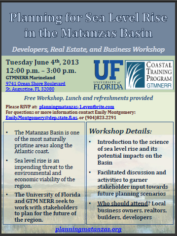
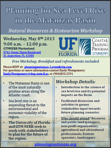
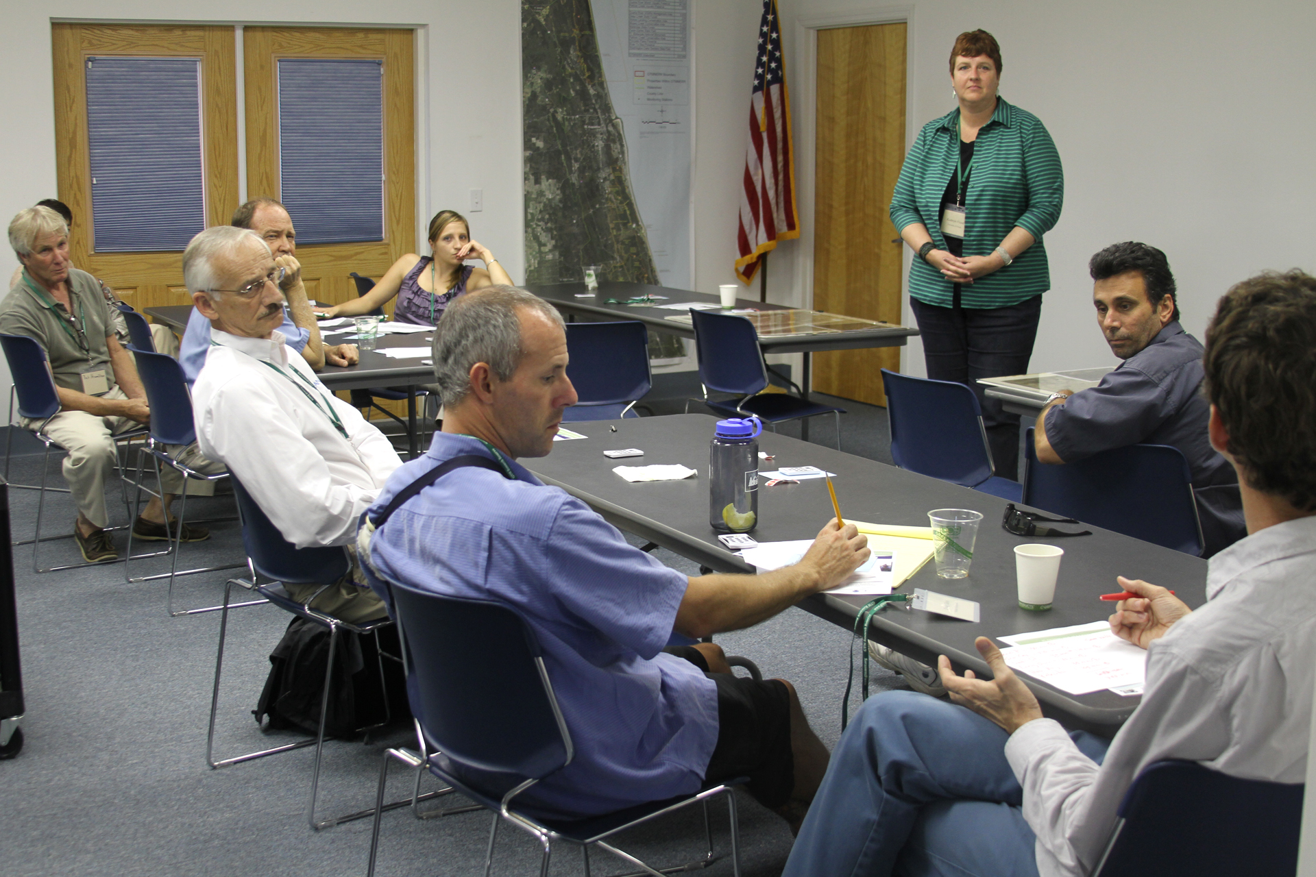
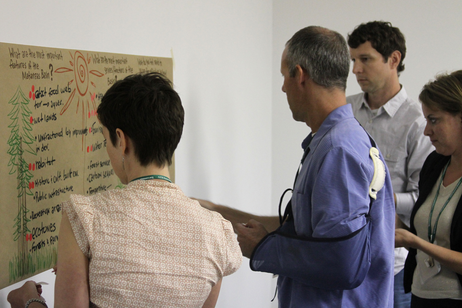
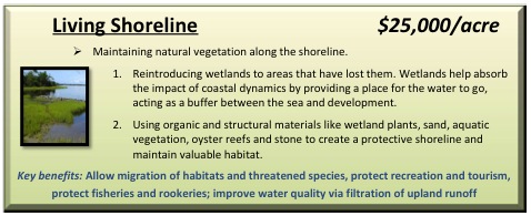
There are several types of sea level rise adaptation strategies used in the planning process to assist coastal communities. Strategies for the built environment can be categorized into three groups based on their objectives:

1. Accommodation – Accommodation strategies adapt to rising water levels through design measures such as elevating infrastructure or implementing stormwater improvements. Although they do not prevent flooding or inundation, they can be suitable for location-dependent structures. Elevating residential homes is an example of an accommodation strategy used along the coast in the Matanzas Basin area.

raisedhome

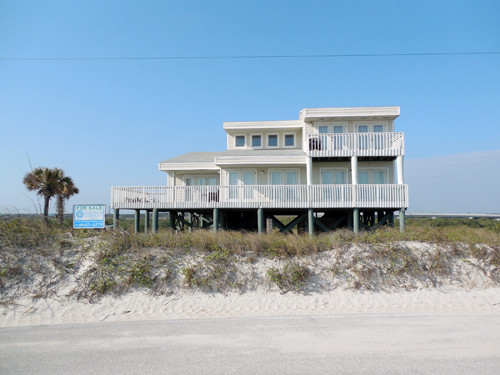
An elevated residential home on A1A in St. Augustine, FL.

2. Protection – Protection strategies mitigate the impacts of rising seas through defensive mechanisms. Armoring is a “hard” protection strategy that is used often in historically significant areas. For instance, seawalls are used in St. Augustine to protect its historic downtown. Beach renourishment is a “soft” protection strategy that is used by coastal communities to decrease vulnerability.

riprapRiprap along A1A, in Vilano Beach. Courtesy of Daron Dean at the St. Augustine Record.

3. Planned Relocation – Planned relocation involves the actual movement of development and infrastructure away from high risk areas. Prompting a relocation includes acquisition of vulnerable areas to prevent future development. Acquisition can occur through transfer of development rights, rollings easements, or conservation easements. St. Augustine witnessed the retreat of infrastructure with the rerouting of A1A Beach Blvd due to increased flooding and inundation.

a1aarrows
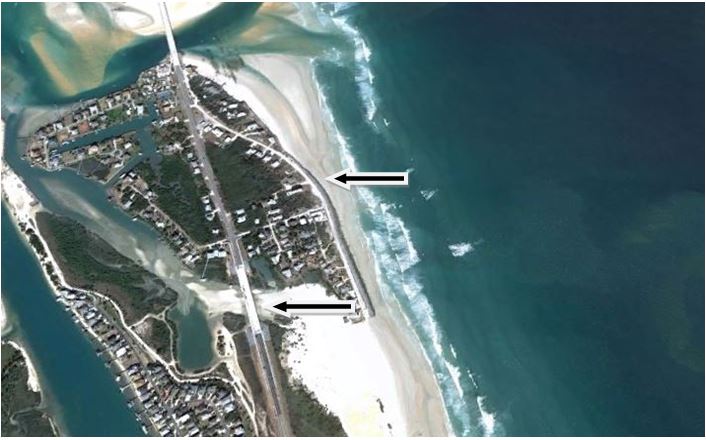
The arrows indicate the locations of the new and old A1A in Summer Haven, FL.

Youth Workshop – Middle School

When sea level rise accelerates, who will it impact the most? The next generation of planners, government officials, residents, and business owners may be young right now, but the importance of informing them and getting them engaged with the issue was not lost on the Matanzas sea level rise project team and steering committee. As with the college and high school student workshops in May, we recently engaged middle school students participating in the summer program at St. Johns Technical High School in St. Augustine to teach them about sea level rise, and to find out what they thought about the issue and what they value in their community.

GTM Research Reserve’s Coastal Training Program Coordinator, Tina Gordon, coordinated with teachers and administrators at St. Johns Technical High School to offer a sea level rise workshop to about 40 students in grades 6-8. The workshop was structured like the previous adult community and professional group formats. The content of the presentations, visioning, and role-play game remained the same, but it was re-worked to meet the curriculum level of the students.

The middle school students were most excited by the visioning exercise in which they told us what places and features were important, what services were important, and what they would do to plan for sea level rise. The students were also a great help in making suggestions to the team on future sea level rise education for their age group, including having students draw pictures of their communities and adaptation strategies. Like other youth participants in our workshops, the middle school students leaned more towards protection of places they loved through fortification such as sea walls than adults (who more often considered planned relocation), and the students desired to keep natural areas natural. The team will incorporate this input into the overall project, Planning for Sea Level Rise in the Matanzas Basin.

The project team would like to thank Linda Krepp and Wayne King for enabling their students’ participation, all of the teachers who assisted in our group activities, and the UF graduate students who facilitated the interactive activities.

Visioning

A student ranks the most important features of the Matanzas Basin and the needs for effective sea level rise planning.

Adaptive Strategy GameStudents play the adaptive strategy game with GTM Research Reserve Coastal Training Program Coordinator, Tina Gordon.

Third Professional Workshop

The third, and last, professional stakeholder workshop of this series was held on June 4th, 2013, in Marineland, FL. Nine participants with backgrounds in development, real estate, and business were welcomed by Micheal Shirley, Director of the GTM Research Reserve. The University of Florida project team then presented participants with an analysis of potential sea level rise impacts to the Matanzas Basin, and a primer on adaptation planning. Afterwards, participants provided input towards future planning scenarios through a visioning exercise and a sea level rise adaption strategy role-play game.

The workshop provided an excellent forum to discuss ways to ensure the Matanzas area’s continued vitality. The project team thanks participants for a productive workshop and engaging conversations. The input provided by participants will inform the next phase of the project that generates maps of future land use scenarios. These maps will be shared with all stakeholder groups and citizens in late fall of 2013.

seaLevelRise_25

Doug Davis (far right) discusses his group’s results from the sea level rise adaptation strategy game.

seaLevelRise_14

Workshop participants identified their top priorities from the visioning exercise by placing a red dot by their preferences.

Project Facebook Page

The Matanzas project has a new Facebook page! The page operates in tandem with the main project website, PlanningMatanzas.org, to apply one of the most powerful social media tools to share the latest project activities and upcoming events. When you visit our Facebook page, “like” it for convenient, timely updates on the project. Liking and sharing the page also promotes the project and helps us reach a wider audience.

facebook page

Sea Level Rise Adaptation Strategy Role-Play Game

Adaptive Strategies Game at Flagler College

Community residents and game developer Briana Ozor (far left) are shown participating in the Sea Level Rise Adaptation Strategy Role-Play Game at Flagler College, St. Augustine, in December 2012.

For our stakeholder workshops, Dr. Dawn Jourdan and University of Florida master’s student Briana Ozor developed a role-play game involving sea level rise adaptation strategies. Participants play in groups of five and each person takes on a different stakeholder persona: local resident, government official, environmental scientist, ecotourism business owner, or inland developer. Each player has a certain amount of money, and the object of the game is to work together to “buy” different sea level rise adaptation strategies to help their community plan for sea level rise. Adaptation strategies include seawalls, beach nourishment, raising buildings, coastal ecosystem restoration, steering future development away from the coast, habitat migration corridors, aquifer recharge easements, and planned relocation of existing coastal development.

The game supports an active, applied learning experience. Not only does the game give workshop participants time to interact with each other, it sparks important dialogue among players as they navigate their roles and select strategies. Participants may explore adaptation strategies that they had not fully considered before. For instance, many players learn about the option of installing living shorelines as an eco-friendly alternative to seawalls. Many participants note the learning benefit of putting sea level rise planning into economic terms. Others note how seemingly opposing viewpoints (the environmental scientist and inland developer, for example) may benefit from the same strategy. Although it can be challenging to play an unfamiliar role or to come to group consensus, players leave the game with a different perspective of sea level rise planning. In the end, participants say the game illustrates the importance of having all stakeholders represented at the table. Through this simulation, it becomes clear that the future of sea level rise adaptation planning depends on collaboration, negotiation, and innovation.

Game Persona Card

Example persona card.

Game strategy card

Example strategy card.

More information is available in this Sea Level Rise Adaptation Strategy Role-Play Game fact sheet. The game materials are available below:

SLR Adaptation Role Play Game Instructions

SLR Adaptation Role Play Game Cards

Game Map

Vulnerable areas map

Youth Version of SLR Adaptation Role Play Game

Professional Workshops

Thank you to everyone who came to the workshops for professional stakeholders on May 8th and 9th. Twenty-six professionals in the fields of natural resources, ecotourism, and local government participated. The workshop agenda was:

Participants had a lot of fun playing the adaptation strategies game, because it enabled them to take on professional personas different from their own. We appreciate participants time and effort, especially since the highly interactive format allowed us to capture important concerns and ideas.

5.9.13

The results from one professional workshop’s visioning exercise showing participants’ opinions about important features and functions of the Matanzas Basin, and ways to ensure effective sea level rise planning. The red stickers indicate top priorities.

The project team will summarize and statistically analyze participants’ adaptation planning preferences. The results will be added to, and compared with, the preferences from other stakeholder workshops. The information will inform the next phase of the project to develop future land use scenarios and an adaptation strategies toolbox for the Matanzas area.

The last professional workshop for developers, real estate and local businesses will be held at the GTM Research Reserve’s Marineland office on June 4th, 12:00-3:00 p.m. Lunch will be provided. Please see the link above to RSVP.

NERRS Science Collaborative Visit

The Matanzas project is funded by the National Estuarine Research Reserve System (NERRS) Science Collaborative, a program administered by the University of New Hampshire. The Science Collaborative program requires the projects it funds to demonstrate ongoing collaboration and applied science to coastal management problems identified by the research reserves.

The Matanzas project’s public and professional workshops are examples of collaborative efforts with intended users. Matanzas area local governments and stakeholders will ultimately use our toolbox of adaptive strategies and scenarios to plan for sea level rise. The project is also designed to be transferable to other reserves within the National Estuarine Research Reserve System. There are 28 research reserves across the country representing different biogeographic regions that are protected for long-term research, water-quality monitoring, education and coastal stewardship.

NERRSmapAs part of the Science Collaborative program’s oversight of the projects it funds, funding program manager Justine Stadler attended our professional workshops on May 8th and 9th. Following the workshops, the project’s Principal Investigator Kathryn Frank and Collaboration Lead Dawn Jourdan showed Justine some of the special places in the Matanzas area. The project team thanks Justine for participating in our collaborative process and joining us for an eco-adventure.

kayakingJustine Stadler (left) and Dawn Jourdan (center) kayaking near Pellicer Creek with guide Brandon Mellin of Ripple Effect Ecotours.

SCbeach

Dawn (left) and Justine walking along the shoreline of Summer Haven near the Matanzas Inlet.

Youth Workshops

matanzas

st.johns

The impacts of sea level rise will become greater over time, affecting today’s youth the most. The Matanzas project Steering Committee members recognized the importance of engaging youth in planning for sea level rise, and the project team welcomed the opportunity.

GTM Research Reserve’s coastal training specialist Tina Gordon coordinated with educators in the Matanzas area to offer sea level rise workshops to about 120 high school students and 30 community college students. The participants were six marine science classes at Matanzas High School in Palm Coast, and two environmental science classes at St. Johns River State College’s campus in St. Augustine.

The workshop format was similar to that involving adult residents and professionals. As with the adult workshops, the youth provided ideas for sea level rise planning through a visioning exercise, and they worked in small groups during the role-play game to develop sea level rise adaptation plans. Despite participating in the same workshop activities, youth participants often reacted differently than adults. For example, the high school students approached sea level rise planning from personal rather than professional perspectives. The students showed a strong attachment to place, and they often favored strategies to fortify the area to make it livable despite sea level rise. Alternatively, participants in the adult workshops more frequently considered planned relocation as a viable adaptation strategy.

The project team thanks Mr. Chris Farrell at St. Johns River State College and Mr. Chris Feist at Matanzas High School for arranging the workshops for their students.

A workshop for middle school level kids will be held on June 26, 2013 as part of a summer camp at St. Johns Technical High School in St. Augustine.

TinaWcardTina Gordon, Coastal Training Specialist at the GTM Research Reserve, holds a giant thank you card presented to the project from Mr. Feist’s marine science students at Matanzas High School.

Upcoming Workshops for Professional Groups

The first set of workshops for professional groups in the Matanzas area, including St. Augustine and Palm Coast, will be held in May and June at the GTM Research Reserve office in Marineland. The first workshop on May 8th, 9:00am-12:00pm, is designed for representatives of natural resource and ecotour businesses. The second workshop on May 9th, 9:00am-12:00pm, is intended for local government officials and planners, and members of state and federal agencies with local interests. The third workshop on June 4th, 12:00-3:00pm, is geared towards urban developers, real estate professionals, and other business and economic development representatives. At each workshop, researchers from the University of Florida will present the science of sea level rise and its potential impacts on the Matanzas area. Workshop facilitators will ask participants for their preferences of what places to protect and what adaptation strategies to use. If you are a professional, please visit Events for specific information and to RSVP for the workshop that is the best fit and most convenient for you. Your participation is important for gaining awareness of important issues of coastal change and how they affect you, and for guiding  integrated planning for community and environmental adaptation.

businessworkshoplocalgovtnaturalresources

Community Resiliency Efforts in Northeast Florida

Northeast Florida

As the Matanzas Basin project proceeds with its focus on natural systems and sea level rise, the Regional Community Institute of Northeast Florida, Inc. (RCI) has been coordinating efforts with UF and the GTM NERR and focusing on sea level rise and potential impacts to the built environment in the seven county Northeast Florida region. RCI is a non-profit which takes advantage of the expertise of regional leaders who volunteer to make policy recommendations to the Northeast Florida Regional Council. RCI’s Emergency Preparedness Committee on Sea Level Rise is currently working with local planners on community resiliency assessments. It anticipates making policy recommendations to the Northeast Florida Regional Council in September/October 2013. Background, documents and contact information are available on the Committee webpage.

Courtesy post by:

Margo Moehring

Executive Director

Regional Community Institute of Northeast Florida

and member of the Matanzas project’s Steering Committee

rcinef